
|
The Parish of Leigh |
|
|
|
The Parish of Leigh |
|
This page will provide a central access to a collection of maps presenting many aspects of the geography of Leigh and District, all of which will also appear on the appropriate pages of the site. At the moment it includes the first of a number of topographical maps of various dates and a series of maps showing the various local government boundaries.
All these maps are high resolution (300dpi) and inevitably this means large files. In order to get the sizes down to an acceptable level I have had to use a very high compression JPEG with resulting loss of quality, and the files are still large. I have put an estimate of the download time with a standard 56 kbit/s modem against the link for each file. These times may be a little bit optimistic as they assume you can get about 4.5 kByte/s effective transfer rate which will not happen if the network is at all busy. Of course, if you have a broadband connection you should have no problem with download time.
Click on the thumbnail or on the link to open the image in a new window (at the moment only one image is available).
 Ordnance Survey one inch map 1843
(840kB, estimated download time 3 min 10 sec)
Digitized by the Leigh OPC from parts of sheets (80NE, 89SW & 89SE) of the Old Series Ordnance Survey 1" map in his personal collection. Surveyed 1839-40 and published 1843. An overprint of township names and boundaries has been added.
Back to top
These local government maps are shown on a common base of township boundaries, as the townships were the basic building blocks of larger local government units. They show no underlying topographical detail, but the boundaries can be related to the topography using the map above.
The notes to the maps are provided as temporary explanatory material until the "Civil Administration" page, which is their natural home, is complete.
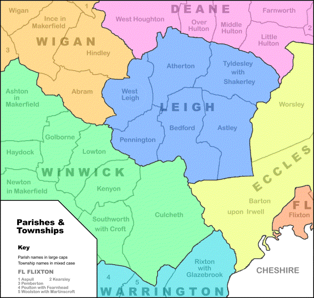
This map illustrates the basic areas of local government from the end of the 16th to the middle of the 19th centuries. It does not show the hundreds which were a relic of mediaeval times. Hundred boundaries changed over the years, but in latter days the parishes of Leigh, Wigan (except Aspull), Winwick and Warrington were in West Derby Hundred, while Deane, Eccles, Flixton and Wigan (Aspull only) were in Salford Hundred.
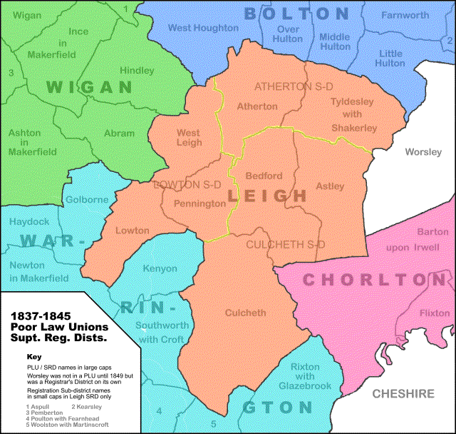
This pair of maps shows the Poor Law Unions introduced in this area in 1837. They shared their boundaries with the Superintendent Registrar's Districts also introduced in 1837. The maps also show, within Leigh SRD only, the Registrar's sub-districts.
The top map shows the situation down to 1845. In that year the township of Golborne was abolished and absorbed by Lowton, and the townships of Kenyon and Culcheth amalgamated as "Newchurch Kenyon". Both these new entities were placed in Leigh PLU.
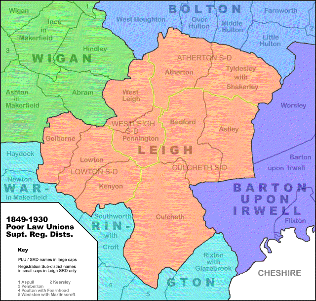
The township mergers turned out to be temporary and so have not been shown on either map (Golborne became independent again in 1850, Culcheth and Kenyon were separated again in 1866) but the change of PLU was permanent and so is shown on the lower map. The lower map also records the creation of Barton upon Irwell PLU and SRD in 1849, although this is outside our area of interest.
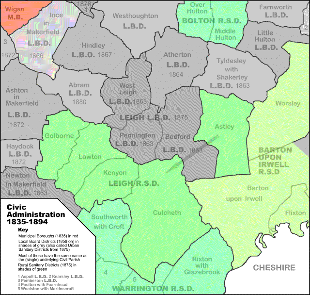
This map shows the efforts made in the 19th century to modernize the system of local government, especially in the rapidly expanding urban areas which were now developing. The earliest civic authorities were the Boroughs, which were corporations created by individual charter. Some (like Wigan, the only one on this map) were ancient but their status was standardized by the Municipal Corporations Act of 1835, which also created new ones.
The next stage was the Local Government Act of 1858 which gave urban townships (or Civil Parishes as they were increasingly being called) the power voluntarily to set up Local Boards to provide for civic improvement, particularly in public health but in practice in a wide range of other fields. The Local Board Districts took the same names as the underlying Civil Parishes so these names have not been repeated on the map. I have given the date of creation for Local Board Districts where I know it; if anyone can advise me of the others I would be very grateful.
Finally the Public Health Acts of 1872 and 1875 made the system compulsory and extended it to rural areas. Most existing Local Board Districts just became Urban Sanitary Districts under the act but there were some amalgamations (including Leigh) and many new Civil Parishes were taken into the system. (The old term "Local Board District" continued in common use, even for those created in 1875 or after). Rural Sanitary Districts were formed on the basis of one for the non-urban part of each Poor Law Union.
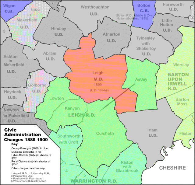
The Local Government Acts of 1888 and 1894 introduced a system which was destined to last in virtually unchanged form until 1974. The 1888 act introduced "Administrative Counties" and "County Boroughs". The former were the old counties (with a few of the larger ones subdivided) but lost several large towns which became County Boroughs totally independent of the counties surrounding them.
The 1894 act introduced Urban and Rural Districts in place of the earlier Local Boards and Sanitary Districts. They were mainly converted on a one-for-one basis but a few new ones were created. Their responsibilities were standardized whereas those of their predecessors had varied.
Leigh became an Urban District under this legislation but within a few years applied for a charter as a Municipal Borough which was granted in 1899
Back to top| Leigh Home and Contents |
©Lancashire OnLine Parish Clerks |
Lancashire Home |