 |
New Row Methodist, Livesey |
|
|
|
New Row Methodist, Livesey |
|
NEW ROW GRAVEYARD AND GRAVE REGISTER
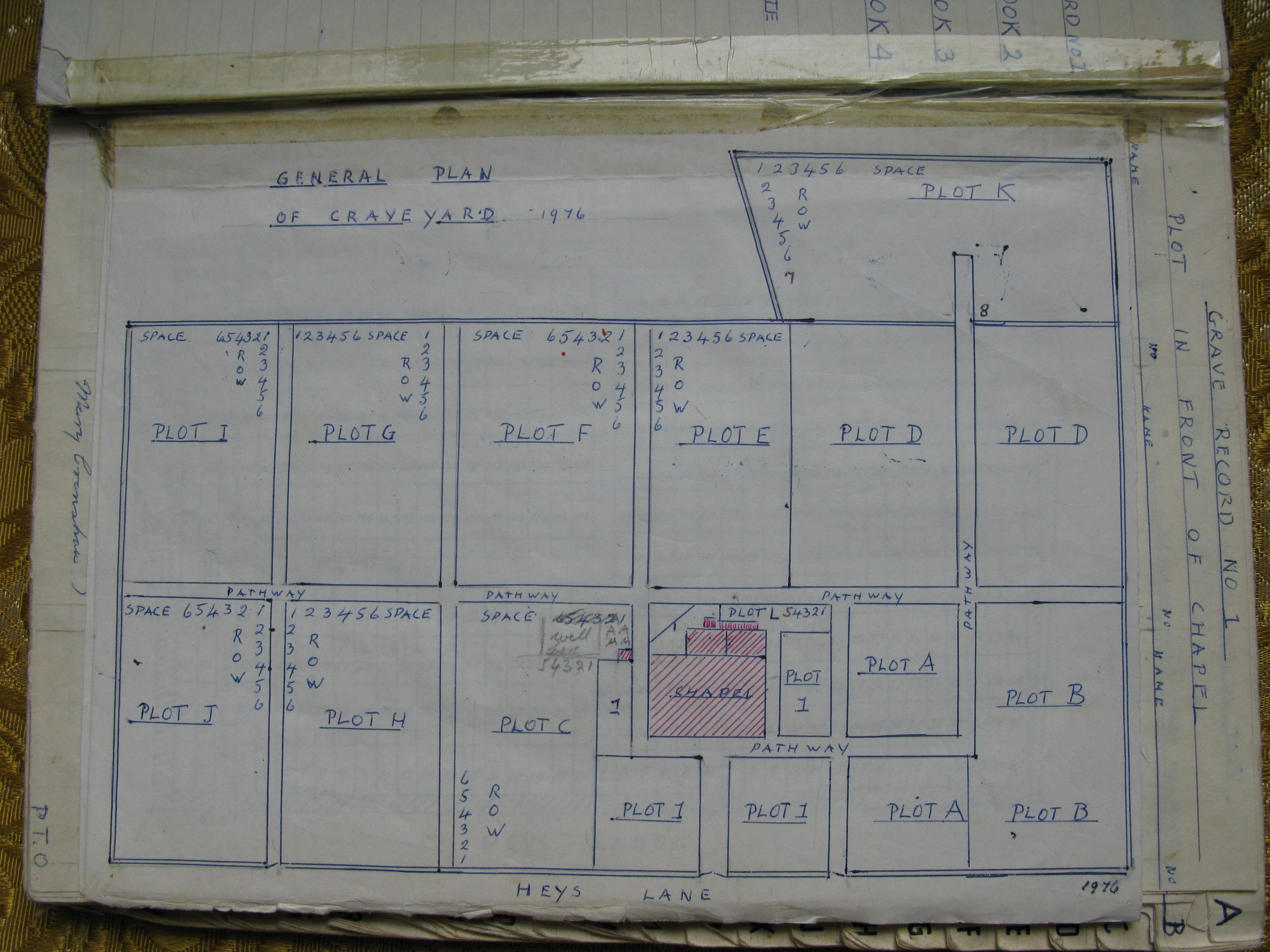
The Graveyard is divided into 13 plots including one small Members Plot behind the Chapel. The Grave Plan shows that here are nearly 2900 grave spaces of which 2800 are actual graves. No burials are recorded for Plot 1 but there are 7331 burials recorded in the remaining plots. With Plot 1 included the figure approaches 8000 burials.
 | |
A higher resolution image is available by clicking the link on the image. This file is over 1Mbyte in size. To download this map to your computer, right click and select 'save Target/Link as'. Do not select 'save image' or you will just get the lower resolution image seen on this page. |
The 'General Plan of Graveyard' drawn up in 1976 gives the overall layout but is not entirely accurate. The exact layout can be seen clearly on Google Earth by entering BB2 4NW. In 1976 specific plans were also made for Plots 1 and A & B.
The Grave Register consists of four books. Apart from Book 1 the registers are £ sterling accounting ledgers. Particularly in the early entries there is much more attention paid to the cost and dates of purchase of the grave space than to the actual names and dates of the burials.
Explanations of the grave numbering systems for each plot are made looking towards the Chapel from Heys Lane.
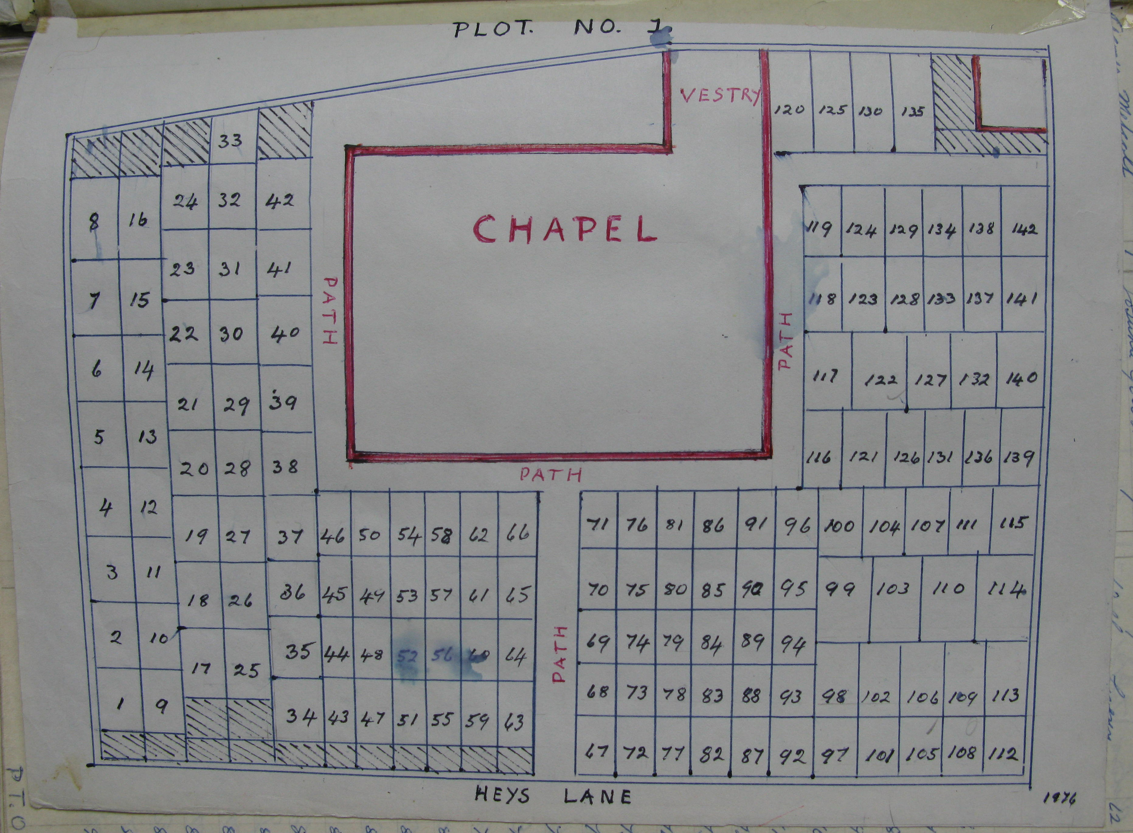
Plot 1 is recorded in Book 1 and is a list of 142 grave numbers with 117 grave purchasers but no burials. The plot is in front and to both sides of the Chapel. The 1976 Plot 1 Plan shows the numbering system for the grave spaces. The numbering starts in the bottom left hand corner of the plot and is in vertical columns. There are very few gravestones still visible and where they are present the names shown do not necessarily correspond to the purchaser's name. This makes it difficult to verify the total accuracy of the plan.
 | |
A higher resolution image is available by clicking the link on the image. This file is over 1Mbyte in size. To download this map to your computer, right click and select 'save Target/Link as'. Do not select 'save image' or you will just get the lower resolution image seen on this page. |
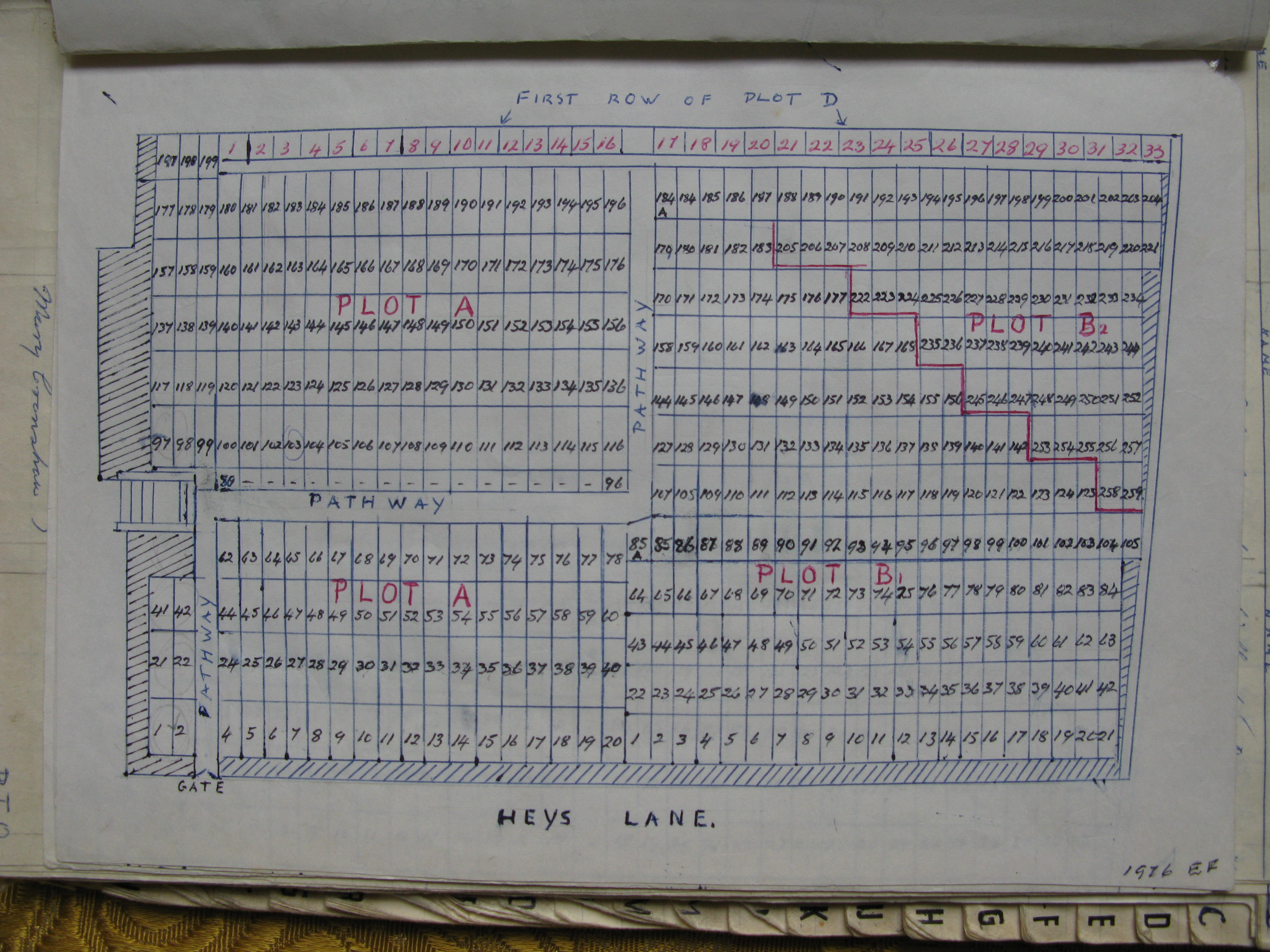
Plot A is recorded in Book 2. It is down the steps and to the right of Plot 1. The 1976 Plot A & B Plan shows the numbering system for the grave spaces. The numbering starts in the bottom left hand corner of the plot and is in 10 horizontal rows with about 20 grave spaces in each row. The fifth row is actually a footpath.
Plot B is recorded in Books 2 and 3. It is to the right of Plot A. Grave spaces 1 to 185 are recorded in Book 2 and 186 to 259 in Book 3. The 1976 Plot A & B Plan shows the plot divided into B1 and B2. The numbering starts in the bottom left hand corner of B1 and is in 12 horizontal rows. The first five rows have 21 grave spaces in each row; the number of spaces then decreases fairly regularly until row 12 has only three spaces. Numbering in B2 then commences in the fourth space of row 12 and completes that row. Row 11 and each row nearer to Heys Lane are then completed with the final two spaces being in row 6.
 | |
A higher resolution image is available by clicking the link on the image. This file is over 1Mbyte in size. To download this map to your computer, right click and select 'save Target/Link as'. Do not select 'save image' or you will just get the lower resolution image seen on this page. |
Plot C is recorded in Book 3. It is to the left of Plot 1. The grave purchases and burials were originally recorded in Book 2 Page 131 onwards. The grave numbering system was confused and records incomplete. It seems that after a number of attempts to amend these records the whole thing was started again in Book 3. The graves are numbered by Row and Space. Row 1 Space 1 is in the bottom right hand corner. There are 12 rows with about 16 graves in each row.
Plot D is recorded in Book 3. It is split in two by a footpath running at right angles to Heys Lane. One part is behind Plot A and the other behind Plot B. The numbering starts in the bottom left hand corner. There are 421 grave numbers arranged in 13 rows with about 33 spaces in each row. The 1976 Graveyard Plan is not correct. The boundary between Plots D and E is a continuation of the line of the footpath between Plot 1 and Plot A at the side of the Chapel. Also the footpath between Plots A & B and Plot D turns at right angles in the bottom left hand corner of D for three rows and it then proceeds again parallel to Heys Lane but further away from the Chapel than the Plan shows. This can be seen clearly on Google Earth.
 | |
A higher resolution image is available by clicking the link on the image. This file is over 1Mbyte in size. To download this map to your computer, right click and select 'save Target/Link as'. Do not select 'save image' or you will just get the lower resolution image seen on this page. |
Plot E is recorded in Book 3. It is to the left of Plot D but not separated from it by any footpath. The graves are numbered by Row and Space. Row 1 Space 1 is in the top left hand corner. There are 10 rows with 24-21 graves in each row.
Plot F is recorded in Book 3. It is to the left of Plot E and is separated from it by a footpath. The graves are numbered by Row and Space. Row 1 Space 1 is in the top right hand corner. There are 10 rows with 20 graves in each row.
Plot G is recorded in Book 4. It is to the left of Plot F and is separated from it by a footpath. The graves are numbered by Row and Space. Row 1 Space 1 is in the top left hand corner. There are 10 rows with 20 graves in each row.
Plot H is recorded in Book 4. It is to the left of Plot C and in front of Plot G separated from both by footpaths. The graves are numbered by Row and Space. Row 1 Space 1 is in the top left hand corner. There are 11 rows with about 20 graves in each row.
Plot I is recorded in Book 4. It is to the left of Plot G and is separated from it by a footpath. The graves are numbered by Row and Space. Row 1 Space 1 is in the top right hand corner. There are 10 rows with 37-29 graves in each row.
Plot J is recorded in Book 4. It is to the left of Plot H and in front of Plot I separated from both by footpaths. The graves are numbered by Row and Space. Row 1 Space 1 is in the top right hand corner. There are 10 rows with 28-22 graves in the first 8 rows and 13 and 6 in the last two.
Plot K is recorded in Book 4. It is behind Plot D and is reached by the footpath, which splits Plot D. The graves are numbered by Row and Space. Row 1 Space 1 is in the top left hand corner. There are six full rows with 48-33 graves in each row. There are two more short rows.
Plot L (Members Plot) is recorded in Book 4. It is just behind the Chapel and consists of four graves.
April 2010
| Blackburn Home & Contents | ©Lancashire OnLine Parish Clerks | Lancashire Home |