 |
The Parish of Atherton |
|
|
|
The Parish of Atherton |
|
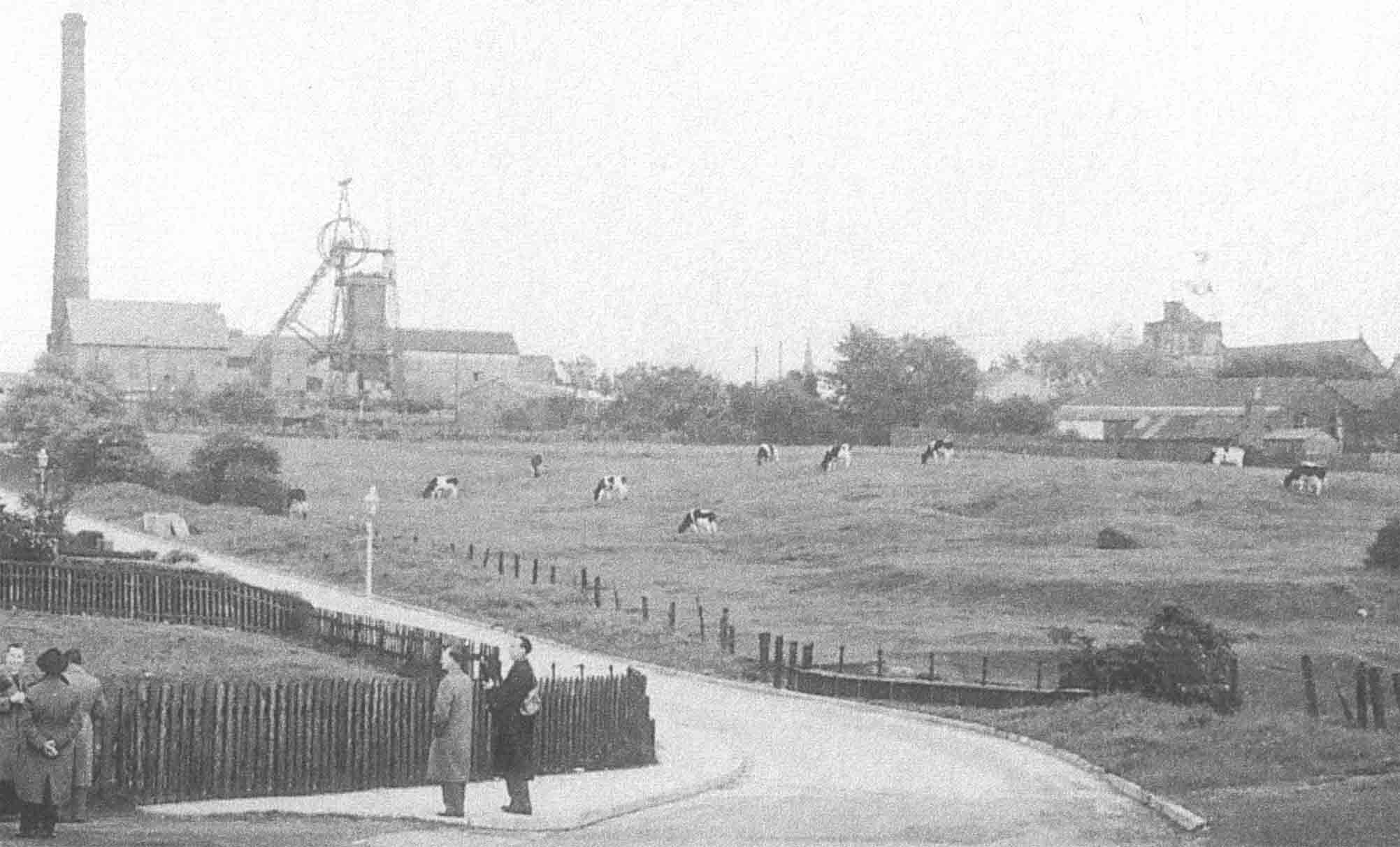
The Pits
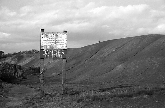
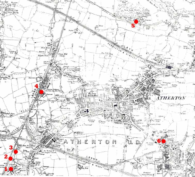
The OS map published in 1909 (6" to 1 mile) shows the collieries where the fatalities occurred. At that time, Howe Bridge, Gibfield, Pretoria and Chanters were working, the Crombouke Day-Eye had just closed but was still marked on the map, while Lovers Lane had been closed and demolished in the preceding ten years. After the Atherton collieries closed in the 1959-66 period, the sites were cleared and renovated, and little is now left to remind the passer by of what was once there. Pretoria was demolished, but the area has not been cleared or built over, and scattered remnants of the pit can still be found lurking in the scrub and woodland that now cover the old rucks and colliery site.
 | |
The Coal Owners
John Fletcher & Others were responsible for sinking the first deep shafts of the Atherton Collieries at Howe Bridge (Lovers Lane, Crombouke Day-Eye and Howe Bridge Collieries), Hindsford (Chanters) and Gibfield. The firm was a Fletcher family affair, but became Fletcher, Burrows and Company in the 1870s when a Liverpool entrepreneur Abraham Burrows, became a partner. Fletcher Burrows & Co. Ltd. was established in 1892 and controlled the Atherton Collieries till 1929 when a number of companies on the SE Lancashire coalfield amalgamated to form Manchester Collieries Ltd. In 1947 the Labour Government nationalised the coal mining industry and from then till closure, the Atherton pits were operated by the National Coal Board.
Howe Bridge Colliery
Leigh Road, Howe Bridge (Colliery 1 on the map: OS Grid Ref. SD 659020)
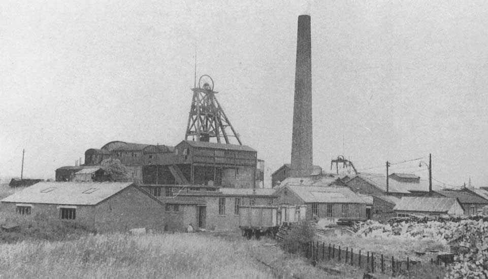 | |
This was the largest and longest-lived of the collieries in the Howe Bridge area. Three shafts were sunk, the Victoria (downcast; to 450 ft at the Black & White, or Seven Foot Mine) in 1850, and the Volunteer (upcast; to 435 ft) and Puffer (water pumping; to 435 ft) in 1860-62. None of the pits were very deep, but the seams were thick and of good quality, and kept the colliery working till September 1959. At closure there were 242 underground and 42 surface workers.
Crombouke Day-Eye Colliery
West of Leigh Road, Howe Bridge (Colliery 2 on the map: OS Grid Ref. SD 660022)
Crombouke was the only drift, or day-eye colliery in Atherton. The engine house and other colliery buildings were located 120 yards south of the Lovers Lane pits. An inclined tramway that passed beneath Leigh Road gave access to the coal of the shallow Brassy and Crombouke Mines (the colliery took its name from the coal seam, not the other way round) under the farmland to the east. An air shaft at Eckersley Fold provided fan-driven ventilation. Opened in 1870, the Crombouke Day-Eye closed in 1907.
Lovers Lane Colliery
Lovers Lane, Howe Bridge (Colliery 3 on the map: OS Grid Ref. SD 661024)
The Lovers Lane shafts were the first deep pits in Atherton, dating from the 1840s. They were the most northerly of the collieries operated by the Fletcher family at Howe Bridge, and also the deepest, reaching the Wigan Six Foot Mine at 900ft depth. In 1872 a firedamp explosion in the Five Foot Mine killed 27 men and boys, the worst single accident in any of the Atherton pits. Lovers Lane colliery closed in 1898.
Gibfield Colliery
Wigan Road (Colliery 4 on the map: OS Grid Ref. SD 665033)
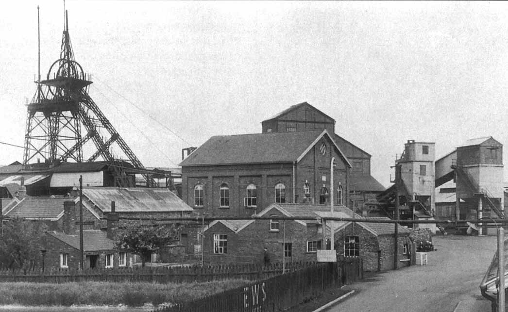 | |
In 1829, a shaft some 300 feet deep was sunk to the Trencherbone (locally the Five Foot) Mine alongside the newly constructed Leigh to Bolton railway, just north of the road to Wigan. Over 40 years passed before sinking commenced in 1872 on the Gibfield Arley Pit, which reached the Arley Mine at 1169ft depth. The Old Gib pit was also deepened and the two shafts served the colliery till a modern upcast shaft was constructed in 1909. By the 1940s the deepest seams, the Arley and Yard Mines, were exhausted, so extraction shifted to the shallower, but previously untouched, Plodder Mine. This kept the colliery working till 1963, when 725 underground and 116 surface workers were laid off. A notable feature of Gibfield’s history was the opening, in September 1913, of the first pit head baths at any colliery in the country; no longer did the colliers return home dirty, to be scrubbed in a tub by the fire.
Pretoria Pit (Hulton Colliery Co. Bank Pits Nos. 3&4)
Hulton Park Estate, Over Hulton, Westhoughton (Colliery 5 on the map: OS Grid Ref. SD 678044)
 | |
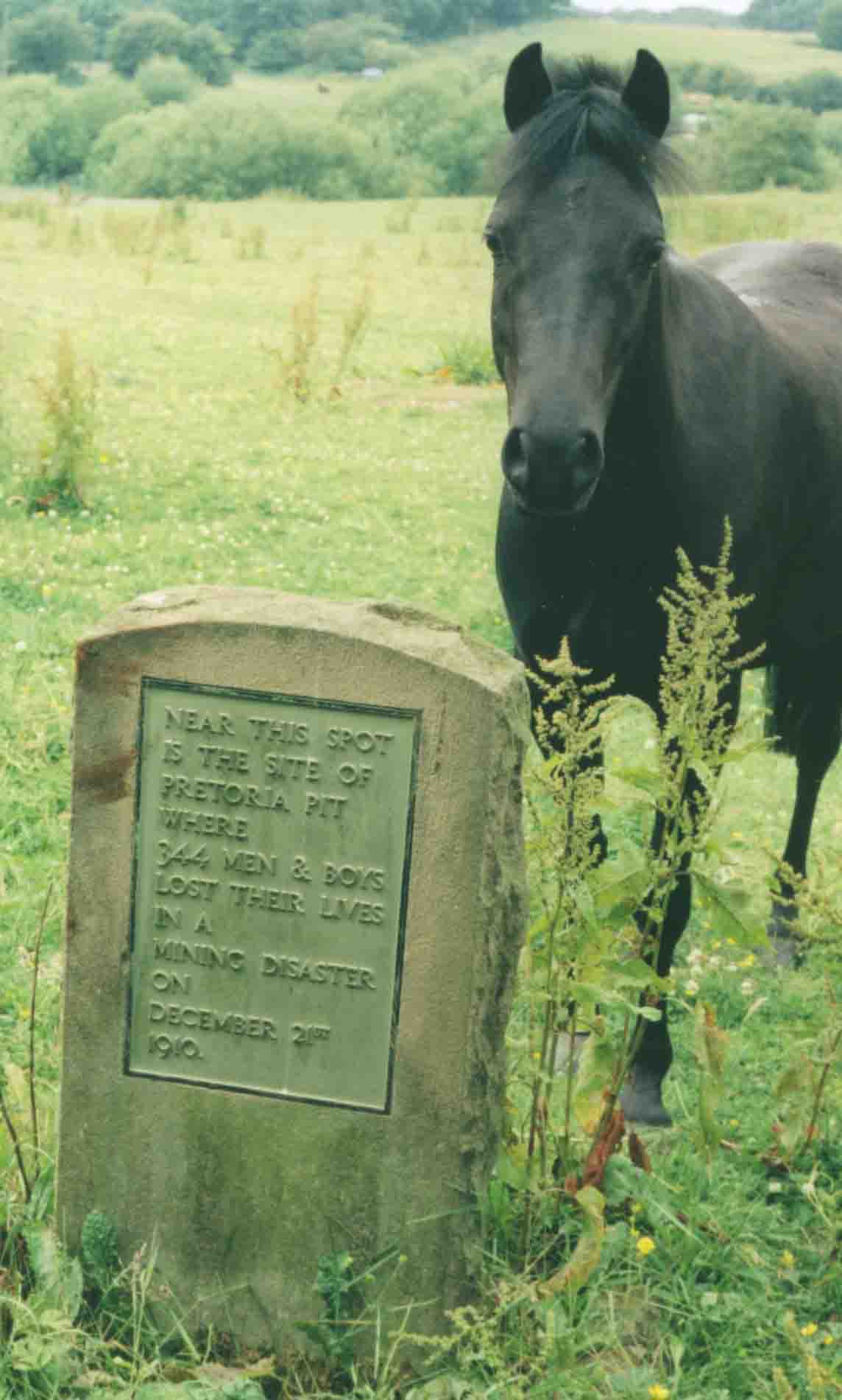
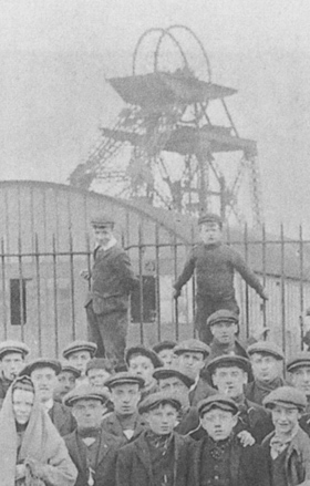
Pretoria Pit was the local name for the most southerly of a group of pits that together comprised the Hulton Colliery. It was located about ¾ of a mile north of Atherton Parish Church, just across the Urban District Boundary with Westhoughton, and was closer to Atherton town centre than the Howe Bridge Colliery. The shafts were sunk in 1900-1901, intersecting the Trencherbone, Plodder and Yard Mines on the way down to the Arley Mine at about 1274 ft.
On 21 December 1910, gas discharging from an extensive roof fall at the Plodder Mine coal face in No.3 pit was ignited, possibly by a defective safety lamp. 344 men and boys died in the resulting explosion and its aftermath, with only three survivors from the devastated workings.
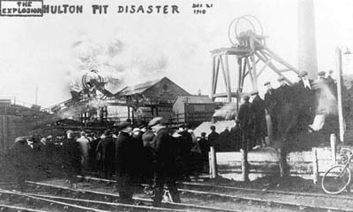 | |
The seams worked from No.4 shaft were not directly affected by the explosion, and over 500 miners were brought safely to the surface from there. The Pretoria disaster was the third worst in British mining history, after the 1866 Barnsley Oaks disaster in Yorkshire (361 deaths), and the 1913 Universal Colliery disaster at Senghenydd, Glamorgan (439 deaths). Most of the Pretoria dead came from Westhoughton, Chequerbent and Daubhill, but 22 miners were from Atherton, and their names are included in the list of fatalities here. |
Pretoria worked on for another 24 years, finally closing with the loss of 750 jobs in March 1934 when the depleted reserves were no longer economical to extract. |
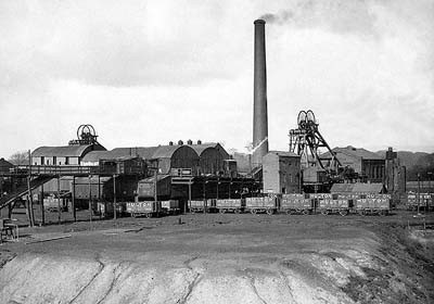
Chanters Colliery
Tyldesley Road, Hindsford (Colliery 6 on the map: OS Grid Ref. SD 683026)
 | |
In 1854, two pit shafts were sunk to the Trencherbone Mine some 1120 ft below surface. No.1 pit was the downcast shaft and main access to the workings. No.2 pit was the upcast furnace shaft for ventilation and emergency use. In the late 1890s the colliery was modernised, both shafts were deepened to reach the Arley Mine at around 1800 ft depth, and furnace ventilation was replaced by a fan driven by a steam engine. Chanters was an early user of electricity, with generators supplying DC power both above and below ground from 1892 on. As the years went by, old seams were exhausted and new seams opened up, while modernisation continued apace. By 1957 the underground workforce peaked at 1066, with 265 surface workers, yet only nine years later in 1966, the era of deep coal mining in Atherton came to an end when Chanters, the last and most successful colliery was closed. |
Acknowledgements
The information was gathered mainly from the books listed on the Resource page. I am especially grateful to Alan Davies, Kenneth Wood and Pam Clarke for their help.
| Atherton Home & Contents | ©Lancashire OnLine Parish Clerks | Lancashire Home |