 |
The Parish of Atherton |
|
|
|
The Parish of Atherton |
|
|
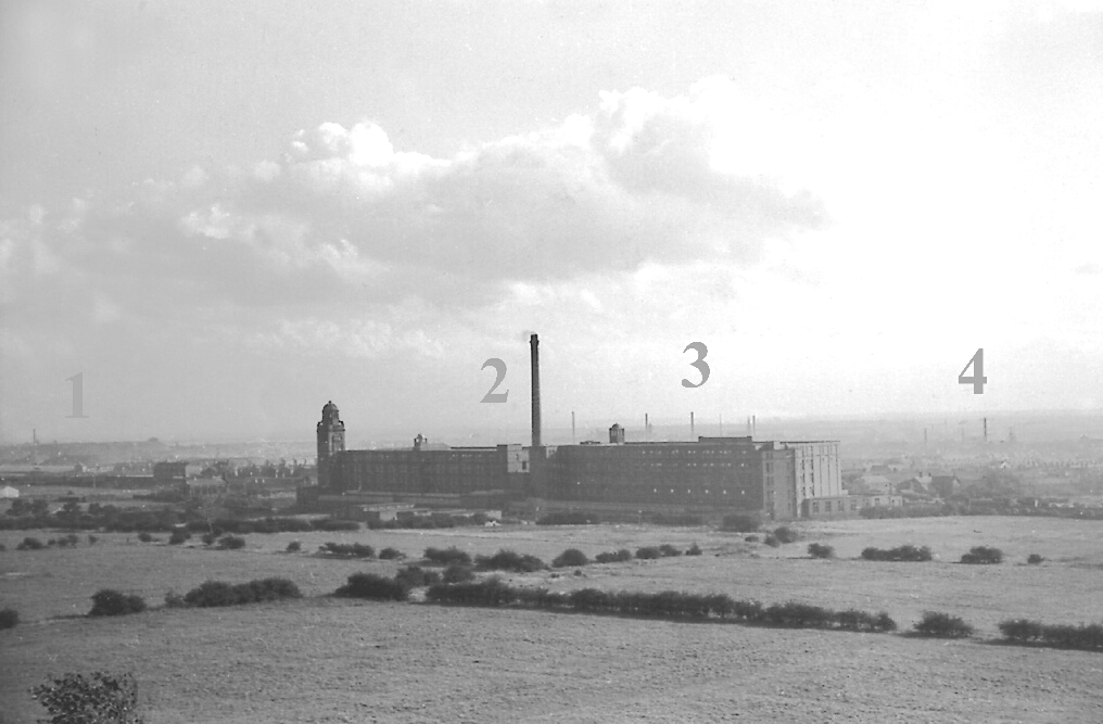
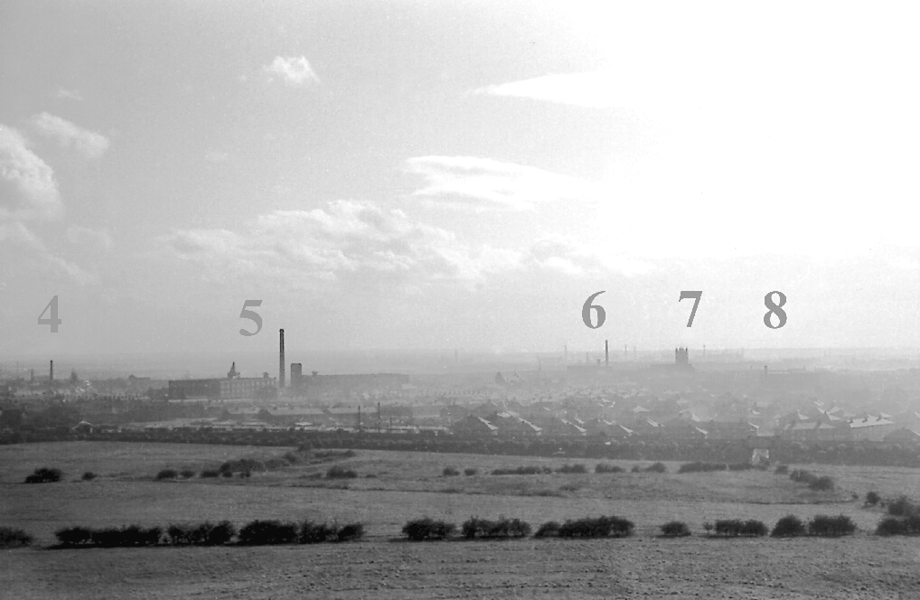
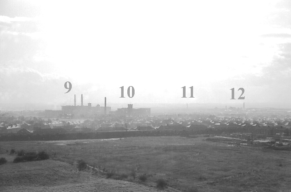
A Panorama of Industry Atherton, a typical workaday South Lancashire town whose population expanded five-fold during Victorian times in response to the demands of heavy industry. I hope this panorama from SE to SW across Atherton in its twilight days when coal, cotton and iron were still king, will give some flavour of how it once was. I took these photos from the top of the Pretoria Rucks just beyond the northern boundary of Atherton, on a beautifully clear afternoon in September 1962. Rucks or ruckings are the local dialect words for colliery spoil heaps, and the blue and red shale mountains of Pretoria dominated the northern skyline for years, a constant reminder of the dangers of deep coal mining. On the 21st December 1910, an explosion occurred in the Yard Mine workings from No.3 shaft of Pretoria Pit, killing 344 men and boys in the 3rd worst mining disaster in British history. Most of the dead came from nearby Westhoughton, but many Atherton families suffered too. The rough pasture lands in the foreground are the remnants of the fields and folds that once surrounded rural Atherton, but have long disappeared under streets and houses. The fields stop at the long, straight embankment of the Manchester-Liverpool railway, and beyond that lies the sprawl of Hag Fold council housing estate. Built from the 1930s through the 1960s, the new houses allowed the demolition of the slums surviving from the mid-19th century, and relieved overcrowding in the long rows of late Victorian terraces. Geographically speaking, Atherton lacks grandeur; it was a place where small brooks flowed through sloping fields and woods in a subdued landscape that, come the industrial revolution, was easily dominated by tall chimneys, cotton mills and pitheads. The Atherton-scape never graced the cover of a chocolate box as far as I know. From East to West on the panorama are: |
 |
|
1. Looking across Shakerley over the rucks of the long-abandoned Nelson Pit, to the rucks of Cleworth Hall Colliery (closed in 1961) in Tyldesley. 2. The Laburnum cotton spinning mills (1905-1982): Atherton Central Station is hidden in a small cutting just to the east. 3. The tall chimneys poking up behind Laburnum are at the Barnfield Cotton Mills, a mile away in Tyldesley (demolished in the 1990s). 4. The chimney and headgear of Chanters Colliery (1854-1966) on Tyldesley Road in Hindsford, as the SE part of Atherton is known. |
 |
|
5. Atherton Spinning Mills (1860-1957) located between the Old and New Bolton Roads; some of the buildings remain as warehouses. Hidden behind the mills are The Valley, Alder House and Chowbent Chapel in the oldest part of the town, known for centuries as Chowbent. 6. Dan Lane cotton spinning & doubling mills; the oldest of the large mill units in Atherton dating from the 1840s with later extensions. It ceased doubling in the 1950s, but some buildings still remain along Lee Street. Dan (Hatton) Lane was one of the oldest roads in Atherton, renamed Tyldesley Road, possibly when the new road to Tyldesley was constructed across Chanters Brook in 1899. 7. St John the Baptist Parish Church, the only distinctive, non-industrial landmark in Atherton. Building commenced in 1878 and finished in 1896. In the distance is a clutter of tall chimneys at a large cotton spinning mill complex in Leigh, 3 miles away (as I said, it was a very clear day - normally the dispersed smoke from the mill chimneys and domestic fireplaces would obscure anything so distant; these days though, you can see Wales). 8. Atherton gas works on Water Street. Not a very grand chimney, and the gas holder merges into the background, but dating from 1835 the gas works is the oldest visible industrial feature on the Atherton-scape (though I don't know if any of the gas works buildings standing in 1962 were that old). |
 |
|
9. Howe Bridge Spinning Mills. Construction of the first mill began in 1868, and it became the largest cotton spinning complex in Atherton, with the 6th mill built as late as 1919. Closed as a textile factory in early 1999, by which time the two tall chimneys and at least two of the mills had been demolished. The mills were near the centre of Atherton, not at Howe Bridge, which is a "village" in the SW corner of Atherton about a mile away. 10. Ena Mill. Ena, later "E" mill on Gloucester Street was built in 1908, and when finally closed in December 1999, was the last of the large textile factories at work in Atherton. The mill and tall chimney still stand, and I hope they keep them for posterity. The Ena chimney and parish church tower are the only landmarks of Atherton visible from up on the moors north of Bolton. 11. Howe Bridge Colliery (c.1840-1959) at the side of Leigh Road, was one of three Atherton Collieries that worked on into the era of nationalisation post-1947, and the first to close. The headgear had probably been taken down by 1962, but the chimney remained visible. 12. The chimney and headgear of Gibfield Arley Mine Colliery (1829-1963) on Wigan Road. In Lancashire, a "mine" was a coal seam, not an actual colliery or pit. The Arley Mine was famous for its high quality coal, but lying at the base of the main coal measures was usually the deepest seam worked, and earned a reputation of being hot and fiery. |
| Atherton Home & Contents | ©Lancashire OnLine Parish Clerks | Lancashire Home |