 |
The Parish of Atherton |
|
|
|
The Parish of Atherton |
|
Atherton or Chowbent
Location
OS Grid Reference: 367400E 403300N (SD 674033)
Latitude & Longitude: 53.53 (N) -2.49 (W)
18 km WNW of Manchester, 6 km SW of Bolton, 10 km E of Wigan, and 4 km NNE of Leigh.
A Town with Two Names
Since 01 April 1974, Atherton and its neighbourhoods of Hag Fold, Hindsford and Howe Bridge, has been a township of the Metropolitan Borough of Wigan, within the Metropolitan County of Greater Manchester. But as anyone from Atherton will tell you, it is an archetypal south Lancashire town with a long industrial and manorial history. It also has two names. Formally the town is Atherton, but for hundreds of years was known as Chowbent, or simply as Bent, the familiar contraction still in use by locals.
From Atherton…
In Anglo Saxon times, the area presented a gently sloping, wooded landscape drained by brooks in small valleys (adre), where a settlement (tun) in an enclosed clearing, gave rise to the name Adurton, first recorded in the 13th century. By the early 14th century the name had stabilised as Atherton, and had been adopted by the 'de Athertons', a Norman family who held the Lodge manor and owed feudal duties to the king's tenants-in-chief, the Botelers of Warrington. Atherton was one of 6 settlements, or chapelries comprising the Parish of Leigh (along with Astley, Bedford, Pennington, Tyldesley and Westleigh), and remained so till 1859 when it achieved the status of an independent parish.
To Chowbent…
The medieval Lords of the Manor of Atherton lived some distance south of the village sited in and around the valley of Chanters Brook, on lands tenanted by the Chow family (a name with variants such as Chew, Chowl and Cholle). Authorities agree that the village became known as Chow's Bent in honour of that yeoman family, but exactly what the Bent was remains a matter of discussion. Perhaps a field, but just as likely it was an Old English word meaning bend, slope or hollow, for the road from Bolton angled down a steepish slope past Chow's place, across the valley of Chanters Brook (an area known then and now as The Valley), and back up the other side. Chow's home and hostelry have long gone, but the name lives on in Chowbent Primary School, built on what were once the Chow family lands on the east side of The Valley.
The first references to Chollebynt appear as early as the 14th century (Ashcroft, 2003), and Chowbent was well known as an alternative name to Atherton in the 16th century, when a royal pardon was issued to "John Atherton of Atherton or the Lodge alias of Chowbent alias Sir John Atherton sheriff of the County of Lancaster" (Lunn, 1971).
And back again…
For 300 years or more, Atherton was subsumed in favour of Chowbent, though both names coexisted, as can be seen on the Ordnance Survey map of 1849 where the town is clearly labelled Chowbent, with Atherton as the general geographical region to the south. Changes in the organisation of local government in response to rapid industrialisation, population growth and urban expansion from the 1850s onwards saw the older name of Atherton gain ascendancy. The Ordnance Survey map of 1894 still called the town Chowbent, but by 1909 even the OS accepted that both the urban district and town had the same name - Atherton. But old habits die hard, and even now at the start of the 21st century, most born and bred Athertonians know they are also Benters.
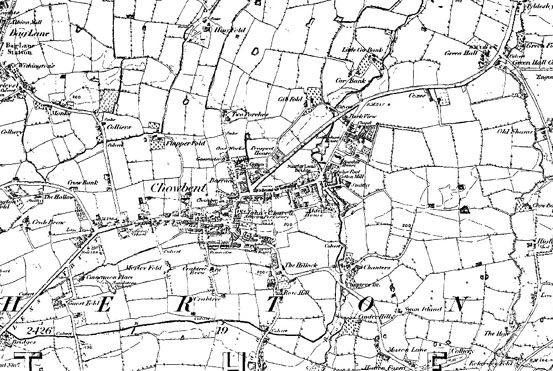 | |
www.old-maps.co.uk service with permission of Landmark Information Group Ltd. and Ordnance Survey |
An enviable reputation?
Maybe urban governmental reform was not the only reason for the name Chowbent to decline in favour of Atherton. The following delightful item, published in The Times of 21 May 1872, suggests the reputation of Chowbenters had spread far beyond the local coalfields and cotton mills - a reputation that the worthies of Atherton were keen to see the back of!
'The grounds of Crystal Palace on a fine Whit Monday present one of the most amusing sights in London, and no one who happened to visit Alderley Edge, Dunham Park, or any of the popular places of resort in the manufacturing districts of the north of England at Whitsuntide could fail to be struck by the great difference in the behaviour and appearance of the holyday folks in the north and south on this occasion. As regards sobriety, demeanour, personal attractions, and, except among the lower classes of Londoners, taste in dress, the comparison tells decidedly in favour of the southerners, as may be seen by paying a visit to Sydenham in the summer, when cheap excursion trains have brought southward some of the Nottingham 'lambs', the workers in the Staffordshire potteries, Yorkshire factory operatives, ironworkers from Sheffield and the Midland districts, the Rochdale 'fellies', and some of the natives of Chowbent, distinguished among their countrymen of Wigan, Bolton and Manchester - but not for politeness. On such occasions it is painful to see the coarse rough horse-play between the men and women, and the great proportion of the men who have evidently been 'soaking' during the whole trip.'
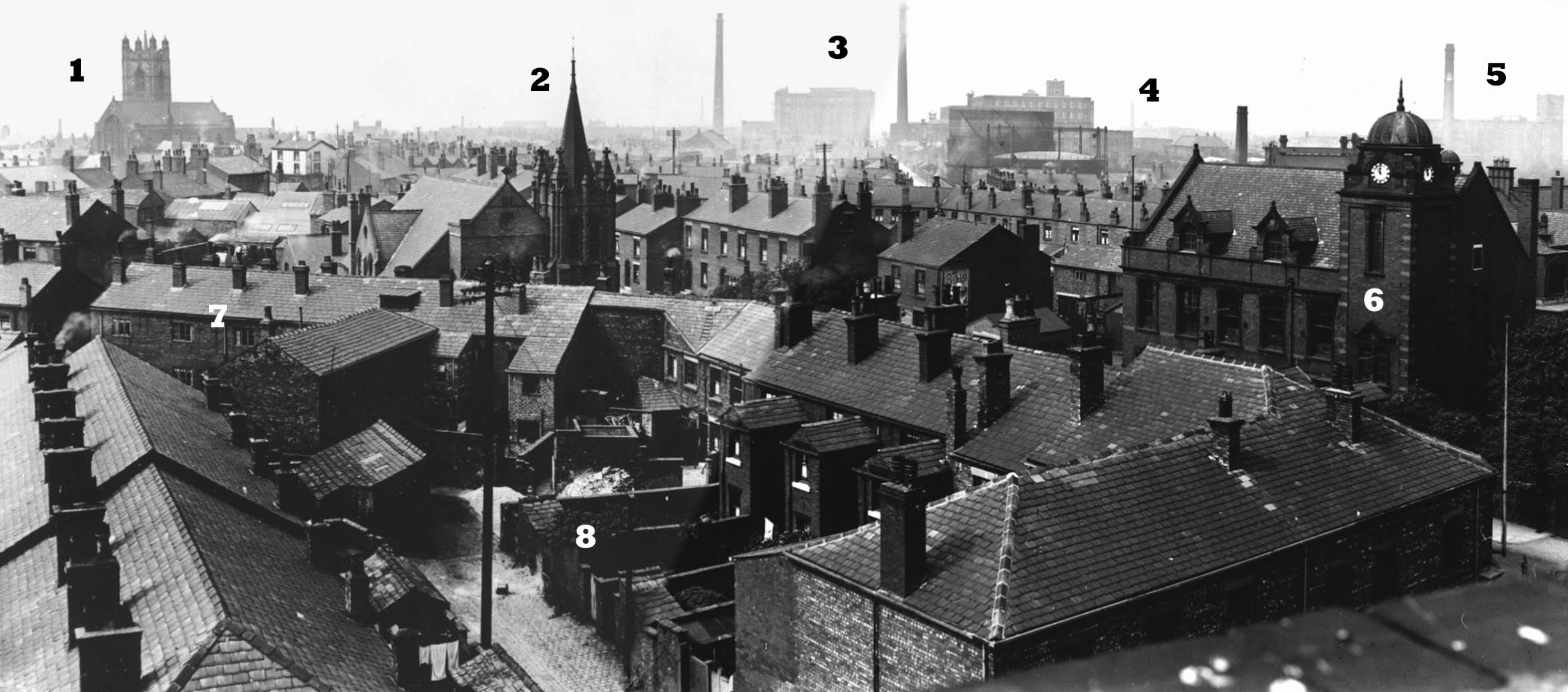 | |
1. St John's Church. 2. Methodist Church on High Street (now demolished). 3.Howe Bridge Cotton Spinning Mills (2 chimneys) with gasworks to fore. 4. Gibfield colliery lurking in the murk. 5. Ena Cotton Mill. 6. Town Hall on Bolton Road. 7. Back view of mid-Victorian terraces on High Street. 8. Typical terrace back street architecture - note the narrow back yards separated by high flagstone walls with a small slate-roofed petty (toilet) at the end. Right click and download the image to view a full size version |
Acknowledgements
Much of the historical information on this site comes from the following publications:-
Ashcroft, Tony (2003) Images of England, Atherton and Tyldesley. Tempus Publishing Limited, Stroud.
Atherton Historical Society (2000) Atherton: a brief history. Lumen Press.
Lunn, John (1971) History of Atherton. Atherton District Council, Atherton.
Wright, J.J. (1921) The story of Chowbent Chapel. Reprinted 2001 by Read Publications Ltd., Leigh.
 |
| Atherton Home & Contents | ©Lancashire OnLine Parish Clerks | Lancashire Home |